This lane nr Lopwell does not seem to feature on the Devon Definitive map and is locally signposted as a permissive path blocked at each end by styles. Should it be on our list?
Sorry to raise it on this part of the forum but I cant get on to the members only parts (could someone fix it for me to be able to view members only pages please}
This lane nr Lopwell does not seem to feature on the Devon Definitive map
IT IS NOT A FOOTPATH/BRIDLEPATH/RESTRICTED BYWAY
and is locally signposted as a permissive path blocked at each end by styles.
NAUGHTY, IT IS AN OFFENCE TO OBSTRUCT A PUBLIC HIGHWAY
Should it be on our list?
IT IS
Sorry to raise it on this part of the forum but I cant get on to the members only parts (could someone fix it for me to be able to view members only pages please}
cheers
Mike
Potus is correct in saying that it has been like that for some time, but the way is recorded on the List of Streets as a highway maintainable at public expense. IE: it is a public road and there is no record of it having been stopped up.
You should contact Devon County Council highways dept and the Public Rights of Way dept and ask both why it is so blocked and when they will be removing the illegal obstruction formed by the stiles along with the misleading notices about it being a permissive path.
They will ignore you, so keep notes of whom you speak to and when. Go back and ask again, and again, and again, and keep asking until they perform their duty. (NB a duty is something they MUST do, they have no choice in law, but they will use lack of funds as an excuse.) No clearing is needed just two stiles to remove.
When I raised this nobody local was interested in taking it on and it is not local to me so I will not bother.
If more than one person raises it it may get attention. If someone offers to remove the obstructions that should shake things up enough to provoke a response. It would only be legal to remove sufficient of the stiles to permit ones motorcycle to pass by. I expect the landowner is responsible with the connivance of the county council, probably because of fears of the proximity of the river.
(It is interesting to note that the yellow road shown on the ordinance survey map as joining the two ends of 201-045 which goes across Maristow park is NOT on the List of Streets and it is not legal to drive a motor vehicle along it since the Natural England & Rural Communities act of 2007 except for access).
There are quite a few UCR's missing in this area (including 045) from the wardens list of UCR's at Devon County but if they are prompted via an email then they can easily research the legality and ownership of land
Depends on how willing people are on wanting to sort the problem
We could be having the same conversation in a few years time
Any chance of some more up to date photos?
I'm at least 1hr + 20 minutes away anyone closer willing to take some photos or better still a video of the correct route of this road?
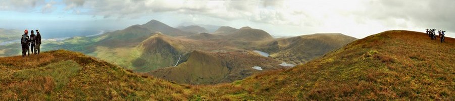
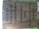
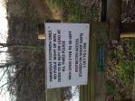
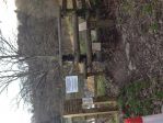
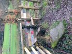
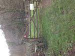
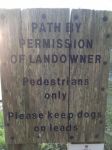
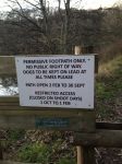
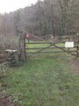
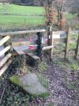
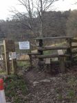
here are some pictures of the lane. There is an access gate at the northernmost end but the southernmost end is completely blocked by a style.
The signage shows this as a permissive path (courtesy of the land owner) and announces closures during the shooting season.
It looks like its part of the Maristow estate.(Lord Roborough owns it I understand). Immediately next to the lane is an area where pheasants are reared (for shooting).
Its a nice ride along the riverside and would be a nice lane to add when crossing lopwell.
There will probably be a lot of vested interest in preventing the use of this lane- especially if it interferes with the shooting and it doesnt show on the map- so should be fun trying.
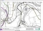
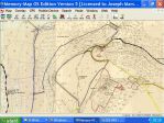
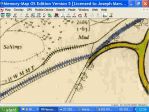
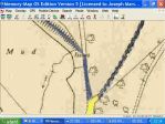
So 202-045 is showing in Black, which is odd because the original DGTRF overlays has it as a UCR, which would me Mantained at Public Expence (MPE) and therefore adopted and should be in brown.
Hopefully Brian will be along shortly with a photo of the original paper LoS.
So 202-045 is showing in Black, which is odd because the original DGTRF overlays has it as a UCR, which would me Mantained at Public Expence (MPE) and therefore adopted and should be in brown.
Hopefully Brian will be along shortly with a photo of the original paper LoS.
Here you are, shown in blue as are all ucrs. Notice that there is no annotation to say the way was stopped up.
Bloody cheek to claim a public road is a 'permissive' path.
Interesting to see that the road through Maristow park is not shown although they have either dedicated it or it has been adopted since as it is now shown on current mapping.
it might be my screen (or my eyes) but the blue is not all that clear to me (not as clear as the other lanes anyway). It may be all of the embankment lines on the map that makes it look different. I have blown it up to 400% and still cant be sure.
I presume you are able to see the map with and without the overlay so the difference is clearer.
Mike
I have blown the map up further to show the detail at both the north end
and the south end of the road.
The word issues does not obscure the blue colouring, denoting a road maintainable at public expense, which is clear and continuous throughout and joins up. That it is not uniformly thick need not concern us as we are not as wide as a car.
I discussed this lane with Rob Drake, who has studied the old mapping and history of the area, and has made a visit and walked the Permissive Path.
He says 'After some local research and investigation on site it would appear the permissive path does not entirely follow the line of the UCR (some of which is now in the River Tavy).
Neither stile is on the line of the UCR.
The permissive path runs entirely along a high made up bank.
As such any part of the route lost to erosion by the river would be lost.
Further investigation may lead to more history and reasoning'
Ive just done the very basic comparison between the old map and google earth. Taking a measured point and using that to establish a relative scale it does look like a good part of the original lane is now in the Tavy
No as it's still, at least in part, a legal lane. The comment has, however, been changed to: "Original line eroded by river so through route lost and with both ends barred this is a lane to avoid."